Geo-Fencing in Drones: Ensure Safe & Legal …
In This Article
- Geo-fencing in drones uses GPS to create virtual flight boundaries.
- It helps prevent unintentional breaches of restricted airspace.
- Drones may use advisory or enforced geo-fencing systems.
- No-fly zones include airports, military areas, and urban centres.
- Geo-fencing enhances safety and supports legal compliance.
- Override functions exist but should only be used legally and responsibly.
- UK drone users must adhere to CAA guidelines and fly within approved zones.
- Flight planning tools improve enforcement of geo-fencing and reduce accidents.
- Many drones come with built-in geo-fencing that updates through firmware.
- Use apps and maps before take-off to remain updated on no-fly areas.
What Is Drone Geo-Fencing?
Introduction to Geo-Fencing
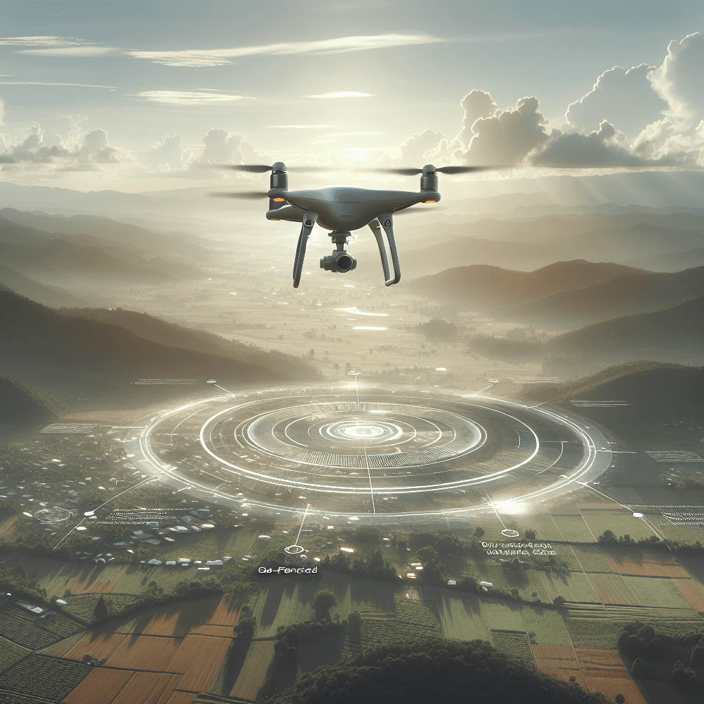
Geo-fencing in drones refers to the use of GPS and navigation software to create virtual geographic boundaries, enabling or restricting drone access to specific airspace zones. It’s a crucial tool for ensuring that drone flights remain within authorised territories and avoid restricted or hazardous areas, such as airports, military zones, and densely populated urban locations. This digital fencing technology has become essential in an era where drone usage is growing rapidly among hobbyists, commercial operators, and public safety agencies.

How Does Geo-Fencing Work on Drones?
Technology Behind Virtual Flight Boundaries
Geo-fencing works by integrating GPS signals with software embedded in the drone’s flight control system. When a pilot initiates take-off, the onboard software communicates with a geo-database containing information about no-fly zones, restricted areas, and regulatory airspace. Using real-time positioning, the system prevents the drone from flying beyond predefined borders. If the drone approaches a boundary, it may automatically slow down, hover, or return to home, depending on the system’s rules and whether the fence is advisory or enforced. Advanced systems even account for altitude restrictions and dynamically update based on time and government alerts.
Types of Geo-Fencing Systems
Advisory vs Enforced Fencing
There are primarily two kinds of geo-fencing in drones: advisory and enforced. Advisory geo-fencing alerts the drone operator via the controller or mobile app, notifying them when their flight path intersects with sensitive airspace. It relies on the pilot to take corrective actions. In contrast, enforced geo-fencing automatically restricts the drone’s movements. It will actively prevent the UAV from entering prohibited zones, overriding any pilot commands if necessary. Some systems use a combination of both, offering flexibility while promoting safety. Understanding the differences is vital when selecting a drone, especially in complex regulatory environments.
Understanding No-Fly Zones
Common Restricted Airspaces
No-fly zones are airspaces where drone operation is either prohibited or heavily regulated. These often include areas near airports, government buildings, nuclear power plants, correctional facilities, and military bases. Urban centres may also implement temporary restrictions during public events, emergencies, or high-risk security incidents. Additionally, certain tourist destinations and wildlife reserves can be included in these zones to mitigate safety and environmental concerns. Geo-fencing in drones helps enforce these limits automatically, ensuring that even inexperienced pilots don’t inadvertently breach laws or endanger public safety. Real-time mapping tools help operators stay up-to-date with temporary no-fly announcements.
Benefits of Geo-Fencing in Drone Operations
Legal & Safety Advantages
The benefits of geo-fencing in drones are significant and far-reaching. From a legal standpoint, it helps operators remain compliant with national and local aviation laws. Violating no-fly zones can result in severe penalties, confiscation of equipment, and even criminal charges. On the safety side, geo-fencing prevents accidental collisions with manned aircraft, buildings, or people. Commercial operators benefit from greater oversight and automation, ensuring consistent adherence to flight regulations. Furthermore, geo-fencing can be used to create safe zones for events or emergency operations, reducing operational complexity for first responders or film crews. In educational or recreational contexts, this technology also supports responsible drone use.
Limitations and Override Scenarios
Can Geofencing Be Disabled?
While geo-fencing offers robust control mechanisms, it is not entirely infallible. Some drones, particularly custom-built or open-source models, allow experienced users to disable or bypass geo-fencing. This capability can be necessary in specific commercial or governmental contexts, such as search-and-rescue missions where reaching restricted areas may be vital. However, unauthorised disabling is illegal in many jurisdictions and poses serious safety risks. Also, updates in firmware and flight apps can affect geo-fencing functionality, creating potential reliability issues. Manufacturers are progressively limiting override capabilities to prevent misuse, but understanding these limitations is critical for any conscientious drone operator.
UK Drone Regulations and Geo-Fencing
Compliance with Civil Aviation Authorities
In the United Kingdom, the Civil Aviation Authority (CAA) governs drone operations and imposes strict rules concerning airspace usage. Geo-fencing in drones is not legally required, but it is strongly encouraged to help pilots comply with Class D airspace boundaries and other restrictions under the UK’s Drone and Model Aircraft Code. Commercial operators must be registered and complete an Operational Authorisation, especially when flying beyond visual line of sight (BVLOS). Many modern drones used in the UK come equipped with automatic geo-fencing aligned to CAA guidelines. Learn more about Drone Regulation and Safety highlights CAA compliance tools that benefit both hobbyists and professional operators in the UK.
Best Practices for Safe Flying
How to Use Geo-Fencing Effectively
To use geo-fencing in drones effectively, operators should regularly update drone firmware and associated mobile applications to access the latest geo-fencing maps and no-fly zones. Pre-flight planning using digital maps ensures clear navigation boundaries. Pilots should test the system in open areas before flying in complex environments. In cases where manual overrides are possible for commercial use, proper licencing and paperwork must accompany those actions. Additional training in understanding local airspace classifications and checking NOTAMs (Notices to Airmen) before each flight is also essential. Implementing these steps ensures operational safety, enhances accountability, and reduces drone-related incidents.
Geofencing-Compatible Drone Models
Consumer and Commercial Options
Most premium and mid-range drones available today support some form of geo-fencing. Leading consumer models from DJI, such as the Mavic 3, Mini 3 Pro, and Air 2S, include enforced geo-fencing with real-time alerts and system lockouts near restricted zones. Commercial UAVs like the DJI Matrice series and Parrot Anafi USA provide advanced configuration options for professional applications. Autel Robotics and Skydio also offer models with addressable fencing features for autonomous missions. When selecting a drone, buyers should consider what degree of geo-fencing control is available, whether advisory or enforced, and if firmware can be customised. Read a related article offers an in-depth comparison of drone platforms and their compliance capabilities.
Apps and Tools for Drone Flight Planning
Using Maps to Detect No-Fly Zones
Flight planning apps are invaluable companions for drone operators. Applications such as DJI Fly, AirMap, Drone Assist (UK-specific), and B4UFLY (US-based) help users identify no-fly zones, understand temporary flight restrictions, and receive real-time weather and NOTAM updates. These apps sync seamlessly with drone controllers and provide up-to-date geo-fencing data overlays on digital maps. They also allow pilots to request authorisation for specific areas through integrated systems like LAANC—Low Altitude Authorisation and Notification Capability. For UK operators, integrating these tools with the CAA’s flying guidance vastly improves safety and legal compliance. Visit How geofencing works in modern drones for a curated list of trusted flight planning apps used across industry sectors.
“Geo-fencing in drones transforms them from mere gadgets to intelligent machines that respect the skies and protect the public.”
Conclusion: Embrace Geo-Fencing for Safer Flights
Geo-fencing in drones represents a pivotal advancement in UAV safety and regulatory compliance. By enforcing digital boundaries, pilots can mitigate risk, respect no-fly zones, and uphold airspace laws with ease. As drones become more integrated into daily operations — from filmmaking and farming to public safety — implementing geo-fencing is no longer optional. It’s a necessity. This technology enables safer skies for everyone and provides peace of mind for drone operators and those affected by their operations. By understanding, respecting, and optimising geo-fencing systems, every drone flight becomes a smarter, safer mission.
Great guide on understanding-geo-fencing-keeping-your-drone-flights-safe-and-legal – Community Feedback
What is geofencing in drones?
Geofencing is a safety technology that uses GPS or RFID to create virtual boundaries. Drones detect these zones and alert or restrict the operator from flying into restricted areas.
Why is geofencing important for drone operations?
Geofencing helps prevent drones from entering restricted or dangerous airspace, ensuring compliance with laws and reducing the risk of accidents.
Do all drones come with geofencing?
Not all drones have built-in geofencing, but many consumer and commercial models offer this feature to promote safe and legal flying.
Can geofencing on a drone be disabled?
Some geofencing systems can be adjusted by the user, while others are mandatory and cannot be disabled, for legal and safety reasons.